The Unbuilt Blue Ridge Parkway is a collaborative project developed in the Fall of 2013 at the University of North Carolina at Chapel Hill by students in Dr. Anne Mitchell Whisnant’s Introduction to Public History course (History 671) working with colleagues in UNC’s Digital Innovation Lab (DIL) under the direction of Lab Manager Dr. Pamella Lach. The collaboration became possible with the summer 2013 debut of DIL’s DH Press WordPress plugin, a tool for creating map-based interpretive projects highlighting digitized primary source materials. The project was completely built (from idea to launch) in 15 weeks.
Dr. Whisnant and Dr. Lach designed the Unbuilt Parkway project to fulfill at least two major aims: to allow students in Public History to practice public history by developing a National Park Service-oriented public interpretive project; and to test DH Press’s compatibility with materials collected and processed for another digital project, Driving Through Time: The Digital Blue Ridge Parkway, a digital collection of Blue Ridge Parkway historical materials created and sustained by Dr. Whisnant and colleagues at the UNC Libraries. Using DH Press in a familiar (to many) WordPress environment in conjunction with Driving Through Time materials provided an accessible, flexible way for public history students to use primary sources to create and present new knowledge in ways that are not possible within the larger (and more technically complex) Driving Through Time environment.
Unbuilt Parkway’s design, research, and technical aspects were closely intertwined, with research informing design and technical development, and technical requirements shaping research and narrative development. Throughout the semester, the project’s content and technical directors (Whisnant, Lach, and two graduate students, Ryan Johnson and Sandra Davidson, supporting the project as part of the Digital Innovation Lab’s Fall 2013 Graduate Practicum in Digital Humanities) met weekly to coordinate activities.
Additionally, members of the technical team visited History 671 class meetings on four occasions to discuss the evolving technical and site design model with the students. The technical model and overall design strategy for the final site changed and evolved in direct response to conversations during these class meetings.
The full final student assignment for the Unbuilt Parkway project may be found here. It, like the overall Unbuilt Parkway project, was developed in close collaboration among the partners so that the assigned tasks would be doable and would serve the end goal. (In practice, this meant that later parts of the assignment were not developed until later in the semester.)
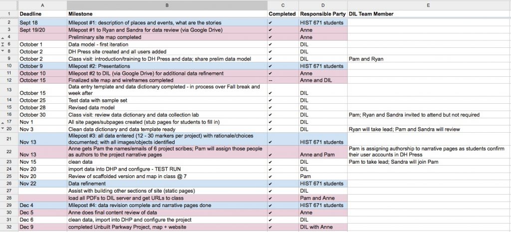
The project involved a good deal of coordination among nineteen people and across two different classes in a very short amount of time. As a result, the team developed an aggressive timetable, with strict deadlines organized around the key phases of the students’ work, called “Mileposts.” In the weekly team meetings, the DIL staff and Dr. Whisnant would review the timetable, adjusting it as required.
Unbuilt Parkway timetable and milestonesResearch
As the assignment details, the project unfolded in four Mileposts. The first two foregounded historical research and narrative development.
Dr. Whisnant and Dr. Lach decided that technical and site design should emerge from the demands of the materials, and the stories that students wanted to tell. Therefore, Dr. Whisnant designed the early assignments to get students going on their research. To expedite the process, she pre-determined the six episodes to be researched and, in early September, assigned the 15 History 671 students to six small groups to tackle them. (Her decisions about grouping were guided by the results of a pre-semester survey that assessed student experience in historical research, writing, and a number of technological tools. She tried to balance each group with an appropriate array of skills.) Although the strategy of assigning topics from the top down did not permit students choice of topic, it effectively prevented them from floundering as they launched their research.
Dr. Whisnant also kick-started the research by directing students to the Driving Through Time site and a selected set of credible and trustworthy Parkway-related primary and secondary sources, gathered here. By late September, additionally, the students completed reading Dr. Whisnant’s book about Parkway history.
On October 9, 2013, the students presented the results of their initial research to former Blue Ridge Parkway superintendent Phil Francis. His feedback and Dr. Whisnant’s helped guide the next phases of research, which were assisted greatly by the re-opening of the federal government (and Blue Ridge Parkway archives) in late October.
Throughout the research process, students benefited significantly from email and in-person assistance from curator Jackie Holt at the Blue Ridge Parkway headquarters in Asheville. Several students traveled to Asheville to do research.
Once the research proceeded far enough, we began to introduce the technical side of the project, particularly the idea that, in order to create the map-based presentation enabled through the DH Press tool, the research findings would have to be reduced to “data” and “data points” that could be mapped. These conversations significantly shaped a fundamental decision to provide site users two points of entry into the stories: a narrative entry page for each episode, and the dynamic, faceted interactive map created through DH Press. Student conversations also influenced overall web design and the development of meaningful categories that would, when mapped, visually provide analytical power across the six episodes.
Technical Development
As the research was beginning in late September and early October, Dr. Lach, working with Davidson and Johnson, provided guidance in the technical aspects of the project. Working with the raw materials provided by student submissions of research materials located for Milepost 1 and an early website design vision developed by Dr. Whisnant in Prezi, the three developed a skeletal website architecture and a data model for the interactive map.
Once the data model was final, the technical team trained the History 671 students (during a dedicated class period) in data collection. Using the Google Drive suite of tools, particularly Google Spreadsheets, the technical team worked with the students to enter the map data and create the site. The team created a data dictionary to guide the students in their data collection. This served as a reference for the students, aiding them in entering and formatting their data according to the specifications necessary for DH Press.
In Mileposts 3 and 4 of the assignment, students continued to do research, and entered the information they had distilled for map markers as data into the Google Data Spreadsheet (each group had its own worksheet). Twice as the data came in, the DIL technical team and Dr. Whisnant checked, edited, and normalized it (cleaning the data to ensure consistency in the various controlled vocabularies). After the second round of data edits, Dr. Lach imported the data into DH Press. The result of this process is the interactive map, where each row of data corresponds to a single marker on the map. Each Unbuilt Project, then, is a collection of 12-30 individual map markers.
Dr. Whisnant and Dr. Lach worked together on other portions of the website’s development. Dr. Lach created an overall page structure for the site, while Dr. Whisnant designed an aesthetic, selecting and posting background and header images and developing a color scheme. She also drafted text for the home page and a longer “Why the Unbuilt Parkway” essay, while Dr. Lach wrote instructions on how to navigate the site. The History 671 students, meanwhile, drafted and posted their own narrative landing pages — longer narrative accounts to supplement and provide context for the interactive map — for each episode, while Lach created the linkages between those narrative pages and the map points developed for each narrative.
One technical feature we were not able to implement in the fall of 2013, but hope to incorporate in the future, is the ability to use the many Driving Through Time georeferenced maps within the Unbuilt Parkway site. These historic maps, which have been aligned with current Google Earth satellite images of the same location, enable users to visualize past, present, built and unbuilt landscapes layered upon one another.


