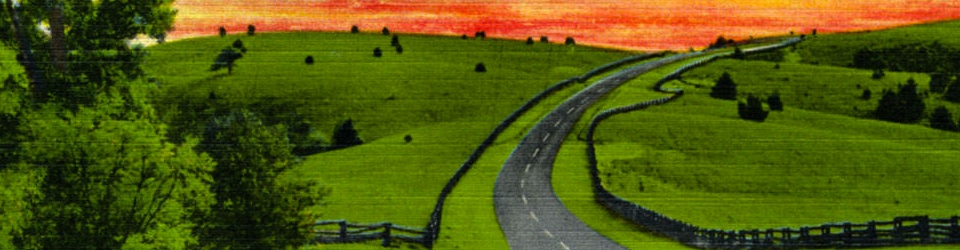

Pine Spur Overlook, Milepost 144, Blue Ridge Parkway, image taken on May 5, 2008. Credit: Dana McMahan
Pine Spur Recreation Area was a proposed recreation area in Virginia along the Blue Ridge Parkway. It was originally intended to host only African-Americans. However, after the National Park Service (NPS) desegregated, the plans for the site made no mention of the race of its visitors. Today (2013), this space is used as a scenic overlook along the Parkway and still has picnic tables available.
Papers on Pine Spur held in the Blue Ridge Parkway Archives in Asheville, North Carolina begin in 1934 and end in 1960. During this period, all correspondence points towards the Pine Spur project moving forward. The full recreation area, however, remains unbuilt and the reasons for the NPS decision to halt the project have yet to be discovered.
Negro Area Development, Pine Spur Park, October 4, 1940
A 1940 Park Service blueprint labeled “Negro Area Development, Pine Spur Park” included plans for cabins, camping and trailer camp areas, gas station, a restaurant, picnic tables, playgrounds, and more[i].
As with nearly all NPS projects, the site was mothballed during World War II, but work resumed in 1945 with another blueprint plan that showed much the same features[ii]. In 1946, Superintendent Sam P. Weems sent a message to the Park Service Regional Director outlining the intent for Pine Spur to be used exclusively as a recreation area for African-American visitors, but that policy of segregation had already been challenged by 1945[iii]. By 1950, all NPS sites in Virginia had been integrated, and it can be assumed that Pine Spur was simply changed to be a recreation area with no mention of the race of its visitors[iv].
Like most NPS projects, Pine Spur’s development stalled between 1946 and 1957. Until land purchases were started again under the funding of Mission 66, no development seems to have taken place.
Pine Spur Play Field, Swings and large tables, Milepost 144, June 30, 1941
In 1941, swings and picnic tables were built as a start of the recreational area. Construction began in early 1941, and the project was completed by the end of the summer. Although it is not known when the swings were removed from the park, the current area only has a few remaining picnic tables though it is not known if they are the originals[v]. When the park plans were revitalized, the restaurant and gas station remained as part of the plans. However it is unclear why the construction of these buildings never occurred[vi].
The National Park Service began acquiring land for both the Parkway right-of-way and for building a recreation area. Pine Spur area lands were originally owned by multiple families, such as the Price, Nichols, and Webb families[vii]. They were offered options to sell their lands to the federal government through programs such as the Resettlement Administration’s Federal Sub-marginal Land Purchase Program, and later the Eastern National Park and Monument Association and Construction Account 347, Acquisition of Land and Water Rights[viii].

Georeferenced overlay of 1934 map depicting Recreation-Service-Scenic Development, Pine Spur (November, 1934). (Click to see full details and overlay on Driving Through Time.)
Two rounds of land purchases happened at Pine Spur. The first round was land purchased for building the Parkway. The purchases for the Parkway right-of-way were completed during the 1935-1937 period with some tracts being bought partially as the land was not needed for the recreation area.
Two stories about the same property owned by C.B. Malcolm and Geo. S. Jack shaped this time period of acquisitions[ix]. In a letter dated June 28, 1935, the owners made their case that the land they own was worth $10,000 and not the $1,650 that it was appraised for. The owners claimed the higher value was appropriate because the tract had a scenic view, and they hoped to develop it into a resort property. This ordeal held up other property purchases for months because the NPS sent letters to adjoining landowners that one of their nearby landowners was asking for exorbitant land prices. Later property land maps show that roughly 10 acres out of the 86 acres available were taken and they cut directly through the middle of the property [x].
It can be assumed that the landowners did not receive their asking price for the land as the response from Assistant Project Manager W.E. Sullivan says: “You have covered your side of the matter very fully, and I am sending your letter to the Richmond office today.” This same piece of land was also described in the Appraisal Report as follows: “In the center of this tract there is a negro graveyard, which has been used by Negros in this vicinity for a number of years. The present owners have endeavored to stop burials in this plot but have failed. The graveyard contains about one-half acre. This is an undesirable feature of this tract.” This cemetery is listed on property maps of the land tract and is located on the first interior U-shaped bend of the Parkway below the Pine Spur Recreation lands. Burials at the cemetery continued until the 1980’s, and today the cemetery difficult to find as it is hidden in the woods[xi].
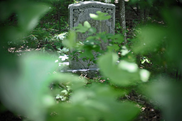
Negro Graveyard at Pine Spur
The second phase of land acquisitions was in the period of 1957 to 1960. NPS was buying multiple properties directly in the middle and surrounding where the Pine Spur Recreation Area was supposed to be[xii]. Two tracts of land, owned by Dora S. Lancaster and Mary Maude Poff Nichols, were the focus of much of the Park Service’s attention. The two properties had enough water flow from their springs to supply water for the proposed development which included: a Lunch and Gift Shop, Gas Station, Sub-Maintenance Area, Campground, and Lodge[xiii]. The plan for development was still strong at the site.
Signs, Pine Spur Park, May 19, 1941.
Pine Spur was a long-term project of the National Park Service. Started under the New Deal, the recreation area never amounted to more than blueprints and a hope that land purchases would allow for construction to begin. Further research may reveal the exact reason for why Pine Spur was not completed but, for reasons unknown, it remains an unbuilt part of the Blue Ridge Parkway.
Pine Spur Service Center, 1945.
[i] B.G.H. “Negro Area Development, Pine Spur Park, 10/4/1940, Drawing No. PKY-BR PS-2050,” Blue Ridge Parkway Map, United States Department of the Interior, available via Driving Through Time at http://dc.lib.unc.edu/cdm/ref/collection/blueridgem/id/1723.
[ii] “Pine Spur Service Center,” 1945, Blue Ridge Parkway Maps, United States Department of the Interior, available via Driving Through Time at http://dc.lib.unc.edu/cdm/ref/collection/blueridgem/id/642.
[iii] Rebecca Jones, “Historic Resource Study African Americans and the Blue Ridge Parkway,” 2009, available at http://mtnlaurel.com/the-slave-meadow/813-historic-resource-study-african-americans-and-the-blue-ridge-parkway.html.
[iv] Reed Engle, “Segregation / Desegregation,” Resource Management Newsletter, January 1996, http://www.nps.gov/shen/historyculture/segregation.htm.
[v] RGH, “Pine Spur Play Field Swings and Large Tables,” Photograph, 30 June 1941, available via Driving Through Time at http://docsouth.unc.edu/blueridgeparkway/content/13221/
[vi] Jones, Rebecca. Historic Resource Study African Americans and the Blue Ridge Parkway. master., 2009. http://mtnlaurel.com/images/slaves/20100125132619.pdf.
[vii] Hillory A. Tolson, “Proposed Acquisition of 37-Acre Nichols Tract, Pine Spur Area, Blue Ridge Parkway,” 10 July 1958, Blue Ridge Parkway Archives, RG 7, Series 5, Box 10, Folder 6.
[viii] Anne Mitchell Whisnant, Super-scenic Motorway : A Blue Ridge Parkway History (Chapel Hill: University of North Carolina Press, 2006), 125.
[ix] Geo. S. Jack, Letter to W.E. Sullivan, 28 June 1935. Blue Ridge Parkway Archives, RG 6, Series 7, Box 5, Folder 6.
[x] “Appalachian National Parkway, Shenandoah-Great Smoky Mountains Section, Recreation-Service-Scenic Development, Pine Spur, Land Map, Nov 1934,” Blue Ridge Parkway Maps, United States Department of the Interior, available via Driving Through Time at http://docsouth.unc.edu/blueridgeparkway/map/1706/BRP_Va_1.
[xi] Diane Tennant, “Part 2: Blue Ridge Parkway at 75 – Buried History” Hamptonroads.com, September 14, 2010, http://hamptonroads.com/2010/09/part-2-blue-ridge-parkway-75-buried-history (accessed November 13, 2013).
[xii] A. L. Altice, “Land Acquisition Map, Pine Spur, post 9/1960,” 1960, Blue Ridge Parkway Maps, United States Department of the Interior, available via Driving Through TIme at http://dc.lib.unc.edu/cdm/ref/collection/blueridgem/id/1726.
[xiii] Sam Weems, “Memorandum for the Regional Direction, Region One,” 08 October 1948, Blue Ridge Parkway Archives, RG 7, Series 5, Box 10, Folder 8.